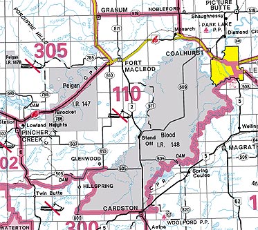
DETAILS FOR WMU 110
Commencing at the junction of highways 3 and 5 at Lethbridge; thence southerly along highway 5 to the southern boundary of the City of Lethbridge; thence westerly along the southern boundary of the City of Lethbridge to the eastern boundary of the Blood Indian Reserve #148; thence southerly, westerly and northeasterly along the eastern, southern and western boundaries of the Blood Indian Reserve to secondary road 505; thence westerly along secondary road 505 to the west side of the bridge crossing the Waterton River; thence westerly and southerly along the northern and western shore of Waterton Reservoir to the right bank of Drywood Creek; thence upstream along the right bank of Drywood Creek to highway 6; thence northerly along highway 6 to highway 3; thence northeasterly along highway 3 to highway 2; thence northerly along highway 2 to secondary road 519; thence easterly along secondary road 519 to highway 23; thence southerly along highway 23 to highway 3; thence southeasterly along highway 3 to the point of commencement.


